Highlights of Day 2:
1. THE BEST VIEWS OF THE ENTIRE TREK
2. Experiencing the change of scenery from alpine to jungle
3. The fun jungle huts and being DONE with the hardest day

Day 2 Stats:
Distance: 22km/ 14 miles
Elevation gain: 3,000 feet
Elevation loss: A whopping 6300 feet
Time: 10 hours
If Day 1 was the warmup, Day 2 was certainly the main event, the big kahunas, the “challenging” day. It also set the precedent for our daily routines. We were woken up at 5 by our guide bringing us Coca tea in our beds. (room service as they called it) and with camp 1 being so cold, the tea was definitely a welcome wakeup. Ater that, we were in for QUITE a day.
We had 30 minutes to prepare for the day, arrange our daypacks and repack our duffels, brush our teeth, and re-stuff our sleeping bags. At 5:30 we met with everyone for breakfast which was a quicker affair than other meals but still delicious. We’d have 4-5 platters of food options, a variety of more teas, a breakfast juice, and at the end we’d get our snacks/ purified water for the day. After eating, we’d have about 10 more minutes to use the toilet, and make ready to go with a depart time targeted for 6AM.

The beautiful sunrise on our glass domes


After a VERY rough night for me stomach wise and freezing I didn’t get much sleep and couldn’t eat much breakfast. Luckily one of our comrades in the group brought Imodium pills which is likely what got me through the day.
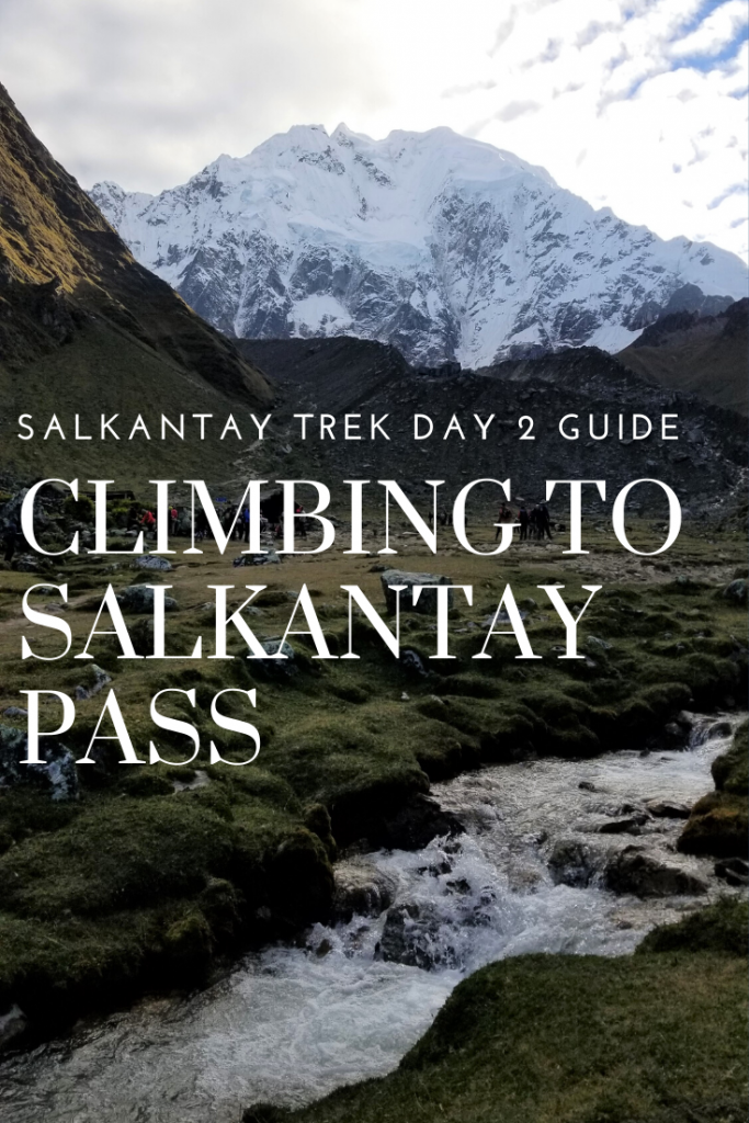
The hike out of camp was mellow for a bout… 10 minutes before starting to climb up. I wasted no time in breaking my hair tie (again thankful for prepared group members who had extras) and it took around 1 hour to get to our first meeting spot above camp and at the base of Salkantay mountain at Salkantaypampa (13625 feet). It was a beautiful morning, perfect weather and with little pink clouds rolling through the valley. We passed multiple streams and a few llamas (a couple which gave us a show…) and from our break stop we could look down on our progress and see our camp down at the bottom of the valley. All in all, not a bad start to the day with just under 1000 feet of gain. (935 feet)

Llamas spotted running through the meadows

Looking back at the start of our day- our first camp is located in the valley just under that cloud

Salkantaypampa
Behind me you can see uphill climb part 2 which is the start of the dreaded seven snakes

The next section of trail (uphill part 2) would be the most difficult. There was a decently steep climb to the base of the infamous “seven snakes” switchbacks and we reached those just as the sun was coming up. While our group started to take breaks to sunscreen up, I carried on until I was at least IN the sun and shedding layers before I bothered with the the sunscreen and even then I tried to keep my momentum going with minimal breaks.
At these switchbacks we ran into the pony trains which got frustrating as we were forced to let lines of horses past us only for them to stop a few switchbacks up and we’d re-pass them. It was also super having the 50+ people who did NOT hike this section all on horseback trying to tell us good job when I was feeling probably as low as I’ve ever felt on an uphill climb. Luckily it wasn’t too long before I reached the top where a bunch of big boulders with awesome views of Salkantay mountain greeted me along with a few fellow people from my group. I met up with them and we continued to the next meeting/ rest spot at Suyrooocha (14,730 feet) to eat a few of our snacks, use the toilet, and prepare for the last assault. All in-all part 2 of the uphill climb was around 1200 feet (we lost about 100 feet after the seven snakes)

Views from the trail of the Seven Snakes. Straight ahead is the right trail (“shortcut” route) which gains about 100 feet less than the switchbacks as it meets up with the main trail later on. The views were better from the seven snakes but in hindsight- I’d have taken the right fork to avoid all the mule trains.
(However our Salkantay Trekking group shirts say “I survived the trail of the Seven Snakes” so… of course I had to do that route instead)

Reaching the top of the switchbacks

Soaking in the sun and views of the incredible Salkantay Mountain

Our break stop was just past all these boulders
After our daily snacks devoured, we set out for the final climb of the day- only 483 feet to Salkantay Pass. It was a fairly steep climb but after about 20 minutes/ bend in the trail, you could see the final destination which always gives you a little burst to get to the top at 15,213 feet.
The pass was COLD.
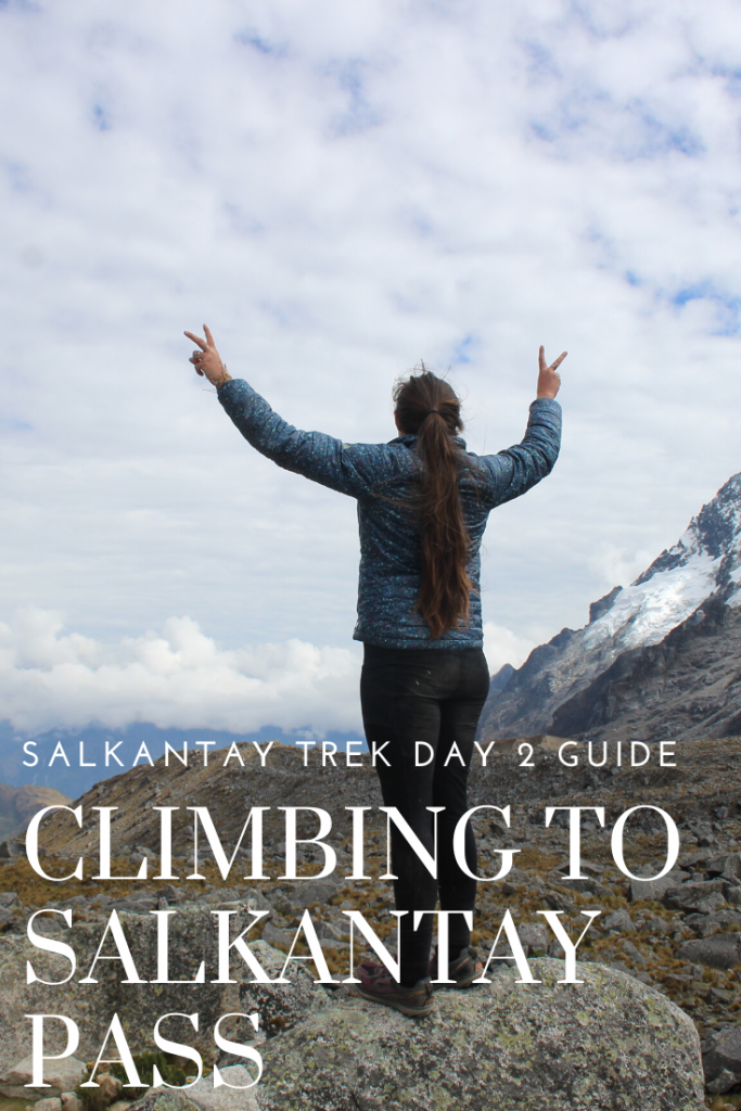
While hiking up in the sun with little to no wind had made us sweat, breaching over the pass was very windy and some clouds rolled in as we got there. It was a godsend however that our cooking crew were there with a big thermos of hot coca tea and baloney/cheese sandwiches (I picked the baloney off and settled for just the cheese) We all layered up and took our group/ individual photos for about 30 minutes before getting ready for the next challenge: the downhill.

Looking up the final hill to the pass


Views from atop Salkantay Pass


Looking back from where we came. The trail curves around to the right base of that mountain.

Once again we created an offering to the mountain with stones each of us collected along the trail and carried up with us.

Right away as we started the descent I could tell this would be my favorite stretch of trail. All around us were big peaks playing hide and peak behind clouds, giant boulders and alpine flowers, all with a huge valley splayed out before us.
We were once again allowed to hike at our own pace so I spent a bit of time walking by myself, and bit of time chatting with others from my group who were nearby. It took quite some time to get to our lunch spot (around 2.5 hours of downhill) at Wayracmachay at 12812 feet so we were all pretty ready for a break. Especially considering we’d already descended 2,401 feet in the span of 2 hours.

Starting the trek downhill from the pass

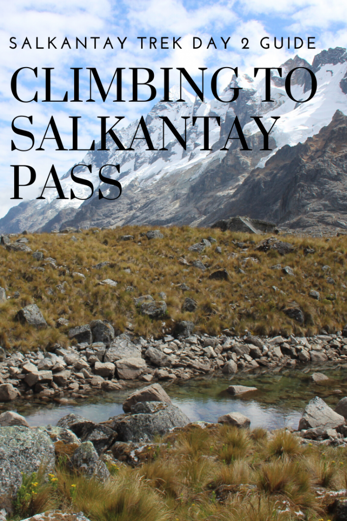
The views of where we were going- it was definitely alpine terrain


Everywhere there were horses and mules grazing- often times amongst old Inca ruins or abandoned farms.


A short breakstop on the way down- only halfway to lunch

Some of the amazing horsemen that carted our stuff ALL THE WAY from our first camp down to our 2nd camp, and then went back up over the pass.

AMAZING TRAIL


Bridge crossings along the trail

The first sign of civilization we saw in a while- still 30 minutes to lunch spot


An interesting pigpen we spotted on our way to lunch.
We finally made it to the tents that contained our lunch. The meal this day was probably one of my favorite meals of the trip. Again we had a small app, soup, and then 6 platters of food including trout which I really liked. We were able to refill our waters (as needed) before then hitting the trail again for another 2,500 feet of loss.

Carlos kept saying it would be more gentle- less rocky after lunch… but honestly it was still just as steep in spots and still a LOT of downhill. If you were using poles, keep them out ! It was definitely a change of scenery as we hit the jungle. Just about everything in the scenery was different and it couldn’t have felt more wild of a transition. There were hummingbirds bigger than my fist, flowers as long as my forearm, and rain forest trees as far as you could see.
Along this route, we only had 1 more meetup stop to make sure everyone was coming and that was at Rayanniyoc (11,460 feet). Bathrooms and snacks were available here and I believe a few people invested in a powerade but most of us were just ready to be done so we didn’t rest for long. Then it was onto the village of Chaullay where our camp would be for the 2nd night at 9,414 feet. (Total loss from the day was 6300 feet!)

Changes of scenery


Break spot

My favorite flower was those yellow ones that look like birds from a distance


The canopy of trees was UNREAL.


Looking back up the trail, you can’t even tell we were just walking amongst rock giants and snow

Our camp here was the most “rustic” as far as toilets went (only 2 stalls with no toilet seats) but was quiet and nice. The huts were up off the ground about 2 feet with little steps to get in and again there were 2 twin beds with super comfortable mattresses.
We did NOT have electricity here but you could pay 10s ($3) for pretty fast wifi and another 10s if you wanted to take a hot shower. As we settled in, people rushed to get on the sign up sheet for showers (30 minute blocks I believe) and others headed for cocktail hour. (Seriously hot cocoa and popcorn after a long day of hiking might be my new go to) We had a little time after cocktail hour to rest but it got dark very fast so there wasn’t much to do besides hang out around the only light- the mess area or sit in the relative dark of the huts.
The early shower blocks were full and as nice as those sounded (literally you could see the steam and hear the people sighing from the open air shower) I knew once it got dark the bugs would be all about that light in there.. so I forgo the shower in favor of the hot springs/ shower I knew we’d get the next day. We had a slightly later dinner at 6:30 but everything was as delicious as before. It wasn’t too long before we were then all headed for our beds ready to pass out after a 26 km day.

Camp 2

Dinner and Dessert- Stir fry and Red corn pudding

Day 2 of the trek extra costs:
$3 for a hot shower
$3 for good wifi
Cash at any of the stands for powerades or sodas.

Pin me: